
By Steve Van Kooten
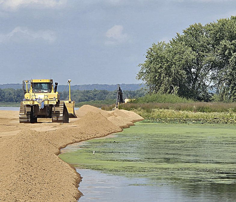
John Henderson stepped foot on Island 25, one of the dozens in the middle of the Mississippi River north of Lock and Dam 10, and examined the freshly laid sand stretching a half mile upstream, making a doughy road a few inches above the water for construction equipment.
The work on 25 is part of a massive habitat rehabilitation project through the Upper Mississippi River Restoration (UMRR) Program that will be done in three phases, starting in the South Ferry Slough, then moving to North Ferry Slough and ending around McMillan Island.
"We're covering about three river miles of restoration in the three phases of this project. What we're doing is almost entirely habitat focused," said Henderson, who is a project manager and civil engineer for the U.S. Army Corps of Engineers - St. Paul District.
Nine islands will be rehabilitated during the first phase of the project. So far, most of the work has taken place on Island 25. In the next two to three years, other islands will be built up and fortified.
"It's all a Lower Pool 10 habitat rehabilitation enhancement project, but it's in different stages due to funding constraints," said Henderson.
The Corps has awarded all of the contracts for the first phase of the project, which costs approximately $11 million. The total cost for all three phases is estimated to be close to $40 million. The goal is to finish the entire project by 2030.
UMRR projects are primarily funded through congressional appropriations and utilize the cooperative efforts of multiple agencies, including the U.S. Fish and Wildlife Service, Department of Natural Resources and a multitude of private sector servicers. Funding for many programs, including the UMRR, is in flux due to the turmoil surrounding the federal budget.
"That is all funding dependent," said Henderson. "All three phases of this project are part of the Upper Mississippi River Restoration Program. That program is usually annually funded through Congress. When those get solicited, all of that depends on when we receive those funds."
The UMRR began in 1986 through an authorization by the Water Resources Development Act. It is the first restoration and monitoring program on a large river system in the United States.
Preserving nature
As Henderson winnowed his boat through the battery of islands, heading toward Guttenberg, the weathering to the islands became more pronounced: trees had withered and toppled over, islands were flattened out like pancakes and some had had entirely sunk below the water's surface.
"As [the trees] die and tip over like that, there's bare soil, and when there's bare soil, that's an opportunity for the river to erode it away. That's why you're seeing some of the islands disappear," said Henderson.
For several islands, all that remained above the river were some broken stumps. Ten years ago, vibrant trees provided valuable habitats for river animals and protection for the island's shores. According to Henderson, the erosion has accelerated over the past decade.
"This whole area used to have trees and floodplain forests. It's destined to look like this if we don't intervene," said Henderson.
The Corps' work aims to address numerous environmental issues within Pool 10. The river's channel has become shallower from the erosion of the islands, which compromises the habitats of various species, including overwintering fish, endangered mussels and even bald eagles, and has decimated the biodiversity of plant species in the area, which has led to the proliferation of harmful species, such as reed canary grass.
"On all of these projects, we take a holistic view of what the pool needs the most," said Henderson. "Very similar to McGregor [Lake], we're seeing a lot of loss from erosion, a lot of mono-topography, invasive grass species taking over and we're losing a lot of the forest habitat the area once had.
"We said, 'Okay, maybe we can put all of these things together under one project and benefit all of these different species and objectives.'"
The Corps has designed new features to help maintain the islands and resist erosion. Some islands have strategically placed rock walls to minimize wear from costal erosion and wind fetch, while others have a built-in sheered edge on their edges to prevent its top soil from being dragged under the water line.
"Each one is a little bit different in terms of what engineers have determined is necessary to help protect it," said Raylene Hylland, a project engineer (manager) for the Pool 10 Restoration. "A lot of that is to raise their elevation to a point where, when we have high-water events, it will help protect the trees. That helps with the habitat."
More than 50 engineers, biologists and technicians have worked on the planning and design for the Pool 10 restoration.
Henderson added that the islands in stages two and three will receive similar treatment as the ones in the South Ferry Slough are getting now.
"The ultimate goal is to maintain the overall health of the river," said Hylland.
Sand and rock
In the South Ferry Slough, nearly in the shadow of Lock and Dam 10, Henderson pointed to a shallow area of the river approximately 150 feet from the nearest island. A decade or two earlier, the water was several feet deeper.
"It's obvious the locks and dams played a part in changing the river," said Henderson. "We're bringing these islands back to what they were before the lock and dams, but we're also making them better."
Dredging is a key component of the island restoration. The sediment used for the base of the islands is repurposed from dredging the river's main channel. It is necessary to maintain the nine-foot navigation thoroughfare for large vessel transportation.
"We're able to beneficially reuse that within the island project," said Henderson.
"For reference, if you were to lay that sand across a football field, it would stand 70 feet tall," said Hylland. The project has already used 50,000 cubic yards of sand.
After sand is laid down, rock from Pattison Sand in McGregor, Iowa, is placed on top.
"Some projects bring it in by truckload," said Hylland. "Instead of driving it all the way down here and loading it at the dock, Pattison has a location where they can load barges on the river. It's really fast and efficient."
After the rocks, fine material dredged from the Bussey Lake area north of Guttenberg is spread over the rock to make topsoil.
Dredged sediment is frequently used for restoration projects. Henderson estimated that the St. Paul District has used approximately 800,000 cubic yards between McGregor Lake and other UMRR work.
For more information and an interactive map of UMRR projects, visit https://www.mvr.usace.army.mil/missions/environmental-stewardship/upper-mississippi-river-restoration/habitat-restoration/find-an-hrep-project/.
