
By Audrey Posten
The Iowa Department of Natural Resources (DNR) is proposing changes related to the water permit modification request made by Pattison Sand Company last year that would reduce the amount of water allocated, monitor water use and shorten the duration of the permit.
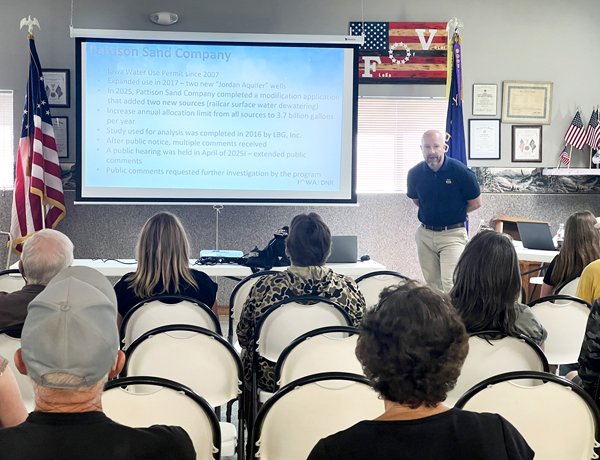
The parameters were announced at a public meeting in Garnavillo on June 9, which also included a presentation by staff from the Iowa Geological Survey (IGS), who shared findings from a study investigating the potential impacts of Pattison’s proposal to up its water usage from nearly 1 billion gallons per year to 3.7 billion.
In the wake of 134 public comments regarding the permit modification and an April 2025 public hearing staff acknowledged didn’t go well, “We decided to retool our water use program and do more of an investigation and give more public involvement and more transparency,” shared Chad Fields, geologist III with the DNR’s water use program. “It’s nice to see everybody here with that in mind.”
IGS hydrogeologist Thomas Doyle said this case isn’t a simple one. Unlike in other parts of the state, the Jordan Aquifer—water withdrawal from which has spurred the most interest—is unconfined in northeast Iowa. It can recharge more quickly because the topography allows surface water to more easily infiltrate, and it does not recharge the aquifer for the rest of Iowa
“The aquifer is continuous across the state, but the flow system isn’t necessarily interconnected across the state,” Doyle said. “Essentially, any water in Clayton County in the aquifer is eventually reaching the Mississippi River.”
The Pattison site near Clayton is also complicated, according to Doyle.
“It’s a very large site and you have lots of different vertical units in it. The water movement isn’t necessarily simple. There’s several wells that are being pumped. There’s several basins that are being pumped, and you have cases where water is being pumped from one basin into another. You’ll also have surface water runoff on your site that’s going to be entering your groundwater system as well,” he explained. “From a water pumping perspective, not all the water that is being proposed to be pumped here is necessarily new groundwater. There’s gonna be a lot that’s recycled groundwater from other sources on site, and also a lot of water that really recently infiltrated the surface runoff.”
Kyle Pattison and other staff from the facility attended last week’s meeting. Pattison said water is used to wash quarried materials, as well as to quarry limestone. Quarrying activity is a beneficial use, according to the Iowa DNR.
IGS conducted a 36-hour pump test, pumping about 3 million gallons of water from two different areas in that span. Doyle said its purpose is to give an idea of the different aquifer parameters—how easily and how quickly water can move through rock in the aquifer.
“The idea of a pumping test is to characterize the aquifer,” Fields elaborated. “Once you characterize the aquifer, your hope is you can take that characterization and see what happens for ‘x’ amount of pumping or ‘x’ amount of days. The pumping tests help you understand what the aquifer can do, not necessarily to stress the aquifer.”
The second part of the investigation was predictive aquifer testing. IGS took information for the site and created a generalized model to predict how the aquifer would respond to the proposed pumping rates.
This data influenced three different scenarios. Under the most likely, IGS said properties within a mile west of Pattison could see water levels in their wells drop by up to four feet. Drawdown as far away as Garnavillo was estimated at less than one foot.
“Based on what we understand about water recycling on the site, as well as the geology of the Mississippi River Alluvial Aquifer and Cambrian Ordovician [Jordan] Aquifer, this is what we believe to be the most likely scenario of the three that we modeled,” Doyle said.
Doyle noted the investigation showed no predicted impact to other aquifers, the Mississippi River or regional springs and headwaters of springs in the area. Under the most unlikely scenario could Turkey River flow and small local streams like Buck Creek be more impacted. There was not enough data to predict if radium could impact water quality.
The latter is one of the data gaps or limitations in the investigation, Doyle acknowledged.
“We always wish that we could collect a lot more information, but with hydrogeologic investigations, we’re always limited on what we’re able to collect,” he said. “There’s no way to capture all the variability in a groundwater system. But based on the pumping tests and the parameters, we’re at least confident the results of it are fairly accurate to what may be expected.”
“The most important data gap is that there is no direct hydraulic evidence that there was that connection between the Mississippi River Alluvial Aquifer and the Cambrian Ordovician Aquifer. The presence of this boundary condition or not kind of dictates how much drawdown you’re going to have in your system regardless of pumping rates. So again, we have really strong geologic evidence that the river and the aquifer are connected, but in our pumping tests that we did, we weren’t able to pump the water levels low enough to the point where we could even start to see if the Mississippi River was providing water to the pumping test. That doesn’t mean there is no recharge boundary condition. It just means we weren’t able to definitively prove it with hydraulic testing data,” he continued. “As I’ve said several times, the Mississippi River Alluvial Aquifer is incised very deep into the Cambrian Ordovician Aquifer, which implies a connection. And also the fact that the water levels in the Cambrian Ordovician Aquifer approach the levels of the Mississippi River also support there being some sort of connection between the two.”
According to Fields, the survey provided the DNR’s water use program with a lot of detailed information to form the conditions of the permit. After receiving the report in February, staff also met with the cities of Garnavillo and Clayton, the Clayton County sanitarian and private well owners who communicated potential well issues.
“We have to make decisions on what we believe is appropriate, safety conditions and safety measures,” he told the roughly 50 people at last week’s meeting. “What matters for most people, what we have rules and regulations on, is environmental considerations to habitat and local wells.”
Based on its analysis and what it believes Pattison needs for the next five years, the water use program is proposing the allocation be decreased 1.4 billion gallons annually—from the 3.7 billion Pattison requested to 2.27 billion from various sources.
“So 2.27 billion gallons per year, we believe supplies them enough water for the foreseeable future for what their facility means,” Fields said. “It’s been a long conversation to figure out what’s the right number here. Even though the model was done at a high rate, there’s still understandable risk to private and public wells.”
Water is only for quarry use, he stressed, referencing previous attempts by the company to ship water by rail car to drought-stricken areas out west.
“A number of comments we got about this permit a while ago were about the water train and shipment of water. That is not an improved water use for this permit, so they cannot use this permit to put water on a rail car and ship it anywhere,” Fields said.
Rather than a full 10 years, the permit will be for five—what Fields called “more of a phased permit increase.”
Additionally, the DNR is requiring placement of a guard well at the southwest corner of the facility that’s existed since 1991 and had water level readings taken since that time. Water levels will be monitored monthly.
“This well was drilled in 1991, and it had a subsequent water level reading taken just last year. With a 2.9 feet difference between the two, we set a trigger level at 189 feet, so six feet from now,” Fields said.
The water use program will also get help from the city of Garnavillo, who does water level measurements every month. Independent data is available going back to at least 2014—and 1956 for one well.
“That information lets us see what’s happening in Garnavillo, and it’s an independent source,” Fields said. “This is not within the permit, but this is understood that we have this sharing of information.”
Lastly, environmental conditions will be added to the permit to protect water in surface streams like nearby Buck Creek, which is currently listed as in impaired water and is important to two federally-listed species, the Iowa Pleistocene Snail and the northern wild monkshood plant. The creek is also critical habitat for the grass pickerel and northern pike fish, who need the correct thermal conditions to survive.
Fields said a package of information was to be released online June 16, including the IGS report, water use program reports, past historical reports, public comments and transcripts from meetings, along with the draft permit. A 21-day formal public comment period will follow. If that goes as planned, he anticipates the permit will be finalized and sent out on July 8.